First of all I want to make it quite clear that I was guided by Geoff Tyrer to the photo which can be found on the flickr website under ‘Stone Marker, Broadgate’. It was taken quite recently by ‘Nog Tow’ who seems to be a mine of information about the history of Preston.
Let’s go back a bit. I started off wondering about the stone marker against the river wall opposite Meath Road. I couldn’t find anything in the Reference Library, couldn’t find anything on the Internet, couldn’t find anyone who knew what it was. So what next?
What next is what I should have done in the first place. I asked in Broadgate News for information. First of all Kath Wallace told me that she’d been told that the stone was there to mark the end of the jurisdiction of Preston Docks.
Then George Cameron remembered ( somehow ) that there had been something in the Lancashire Evening Post back around 1990. He was pretty sure that the article in the paper mentioned that the inscription stood for Eastern Quay Legal Boundary. This ended the limit of Port Dues.
And finally Geoff handed me a print out containing the above photograph together with the following ( and many thanks to everyone for their help ):
This stone marker ( one of two – the other is missing ) marked the eastern boundary ( EB ) of the Legal Quays ( Lc ) of the Port of Preston Customs Area that was set up by the Ribble Navigation Committee in 1844. The way the ‘4’ was represented had yet to be standardized. It was common to see it backwards now and then. There are at least 2 gravestones in Preston churchyards with backward ‘4’s. – Nog Tow.
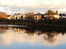
Broadgate overlooking the Ribble
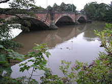
Bridge over the Ribble

Gujurati Hindu Temple, Broadgate

Fishergate Hill, Preston
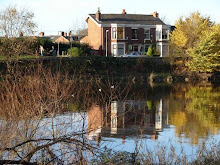
Broadgate Sunshine

Intricate Temple Carvings
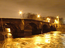
Old Bridge By Night
Preston's Best Blog List
-
-
Whim4 years ago
-
-
-
-
-
-
-
Spate River10 years ago
-
Designer Dog: Jorkie11 years ago
-
-
Tell us your Broadgate story13 years ago
-
-
-
-
-
Cheerio!15 years ago
-
-
Bye Bye....16 years ago
-
Warplane may be built near M6 in Preston16 years ago
-
-
Preston Blog is moving to Blog Preston16 years ago
-
-
-
-
-
-
-
-
-


3 comments:
Great post Terry!
Well not about this actually, but I assume it is by the same Terry who writes a page for Broadgate News? If so, and as there is not one contact address/email listed in that mag anywhere (despite it saying that 'Terry wants your comments' - how I don't know!), I just wanted to say in response to his latest column that Ordnance Survey originates from the Napoleonic wars when it was feared France would invade England. As a result of this fear the army wanted a complete set of maps to know the best places to fight, and more importantly to station their canons (the 'ordnance') in terms of hills and other elevation (hence all the contours that you don't get on a road map!). When the fear of invasion passed they were de-classifide so to speak and became available to the public, as they have been ever since...
Jim, Broadgate.
Hello
I have read a couple of old newspaper articles about the regatta they used to hold on the river. It mentions that races start at the Old Quay to Broadgate Milestone (1 Mile) and also another race that starts at Broadgate milestone to Tram Bridge (1 mile) if you would like me to send you the articles please let me have an email address. Regards Heather
Post a Comment